


Storm to move south of Ca Mau
Sonamu, the first storm in the East Sea in 2013, is moving west - southwest towards the sea area south of Vietnam’s Ca Mau peninsula, said the National Hydro-Meteorological Forecasting Center.
At 4 am today, January 5, the storm was located near the Truong Sa Lon Island, part of Vietnam’s Truong Sa (Spratly) archipelago, packing winds of 75-88 km and gusts of 103-132 kph.
The storm is moving between west and southwest at 10-15 km
and will be seen about 320 km east-southeast of Con Dao Island, with the same
winds, at 4 am Sunday. 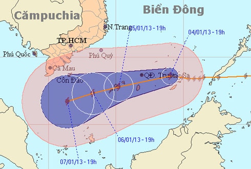
The expected path of the tropical storm
In the next 24 hours, the storm will continue to move west-southwest at 10 kph towards the sea area south of the Ca Mau Peninsula, which includes Ca Mau, Bac Lieu and Soc Trang provinces.
The storm, which is combining with strong seasonal southwest winds, will also cause rough seas in the middle and southern areas of the East Sea, including the sea of Truong Sa, with winds of 40- 62 kph. In the area near the storm’s eye the wind will be stronger, at 63-87 kph, with gusts of up to 132 kph.
The storm will also cause rough seas in the coastal area between Binh Thuan and Ca Mau provinces, with winds of 40-62 kph and gusts of up to 75 kph.
Nguyen Long Hoai, chief of the Ca Mau Province Steering Board for Flood and Storm Prevention and Control, said that the authorities have kept 1,000 fishing boats with about 9,000 fishermen on bard well informed of the storm’s movement so that they can take safety measures in time.
The authorities of Bac Lieu and Soc Trang have prepared plans to evacuate people in several districts for safety reasons when necessary.
TTO